
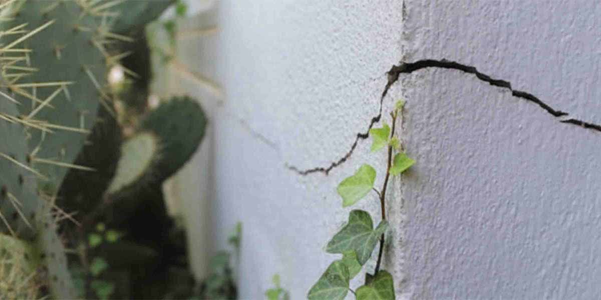
What is clay shrink-swell subsidence?
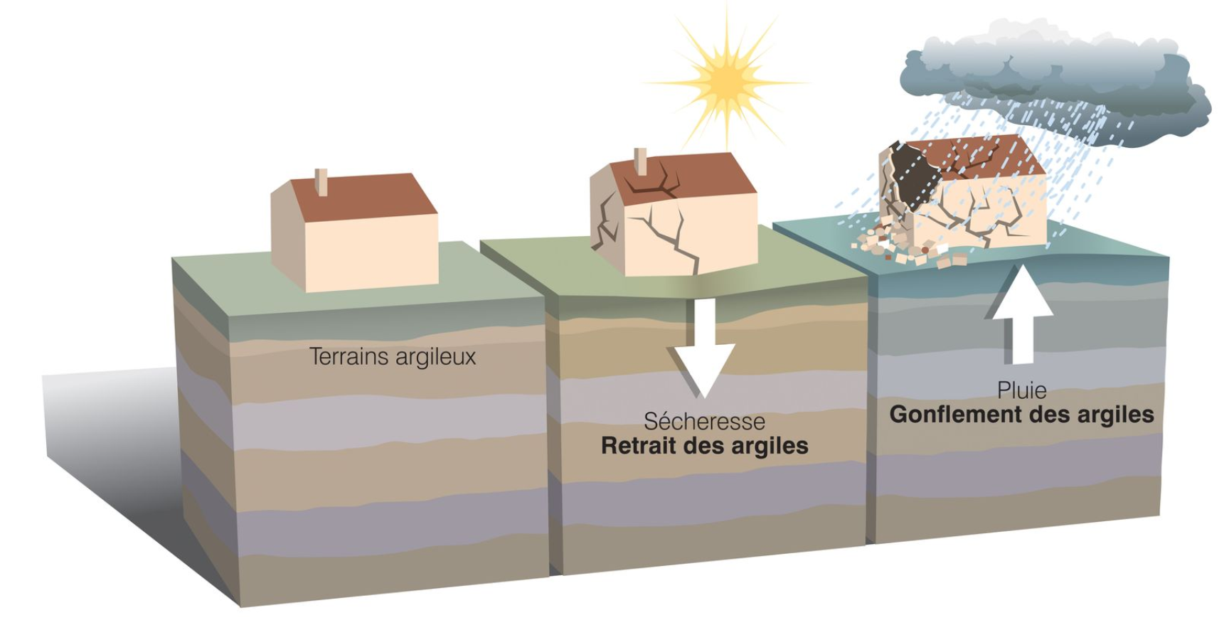
Clay shrink-swell subsidence is a natural physical phenomenon in which clay soils change volume depending on their water content. During droughts, clay contracts (shrinks), then swells again during rainy periods. These repeated volumetric changes cause differential ground movement that can damage building foundations.
From a geotechnical standpoint, this phenomenon results from the particular physico-chemical properties of clay minerals. Clay platelets, especially smectites and montmorillonites, have a variable water-absorption capacity that directly alters their crystalline structure. When water infiltrates between the platelets, the material swells; conversely, drying brings the platelets closer together, causing volumetric shrinkage.
RGA is the second-largest natural disaster compensation category in France after flooding, with an average cost estimated at over €1.5 billion per year since 2000.
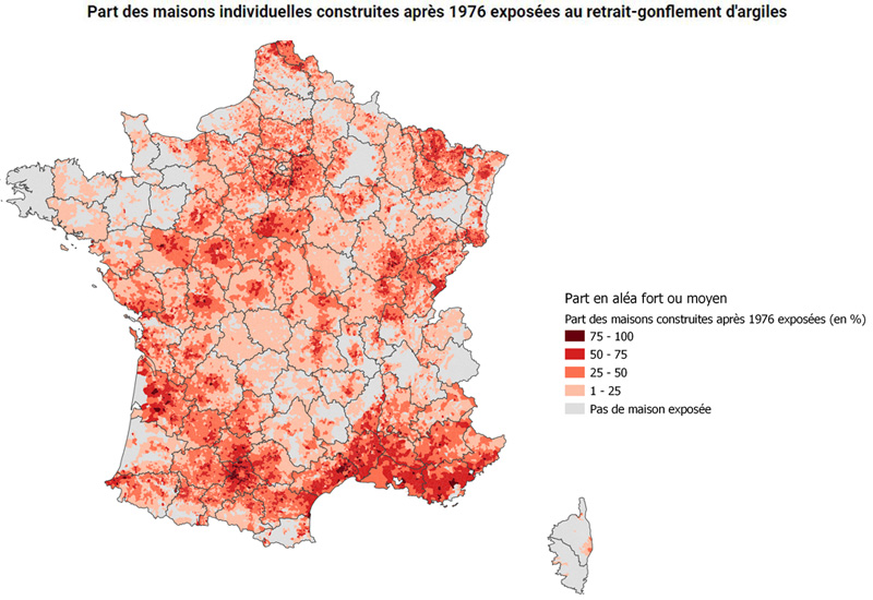
- •Over 10 million single-family homes located in medium-to-high hazard zones
- •54% of French territory affected by at least a low hazard level
- •More than 18,000 municipalities recognized as natural disaster zones for this reason since 1989 [1]
Why does it affect some regions more than others?
Sensitivity to RGA mainly depends on soil geology. Regions with outcropping or sub-outcropping clay formations, such as sedimentary basins, are most exposed. Official mapping available on Géorisques identifies three priority risk zones: the Southwest (Haute-Garonne, Tarn-et-Garonne), Centre-Val de Loire, and Île-de-France.
In practice, several factors determine the local risk level:
- •Soil lithology: presence of smectites, illites or kaolinites, each with different swelling rates
- •Clay layer thickness: the thicker it is, the more pronounced the volumetric variations can be
- •Groundwater depth: a shallow water table limits water variations, a deep one increases risk
- •Local climate: alternating dry and wet periods, intensity of summer droughts
The shrink-swell hazard map available on Géorisques classifies the entire territory into four levels: low, medium, high or very high exposure. This mapping relies on geological data at a 1:50,000 scale and is a reference tool for risk assessment.
How is the risk evolving with climate change?
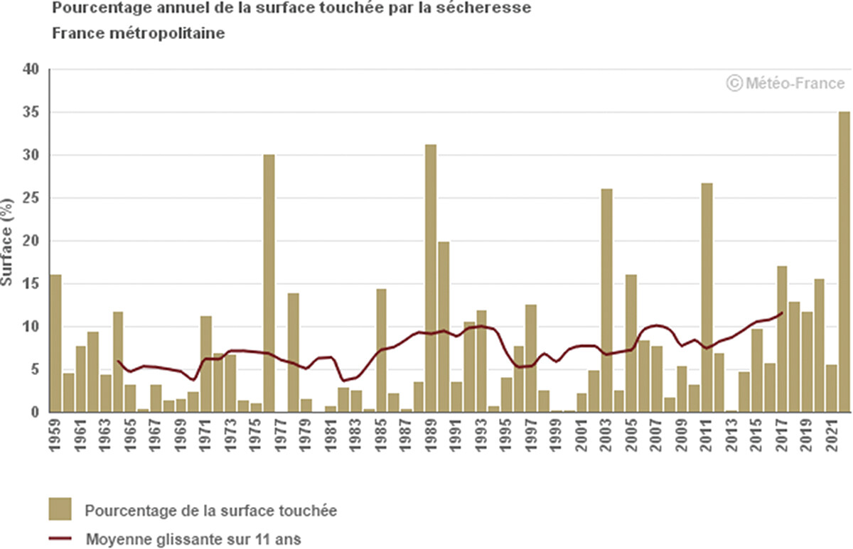
Climate projections from the IPCC and Météo-France indicate an increase in the frequency and intensity of droughts in mainland France. This trend amplifies shrink-swell subsidence, particularly in regions that were previously only moderately exposed. Forecast models suggest a northward geographic expansion of the risk and worsening damage in already sensitive areas.
In concrete terms, climate change is altering several parameters:
- •Longer drought periods: between 1959 and 2021, the frequency of summer droughts increased by 30% on average across the territory [3]
- •Intensified rainfall episodes: a sharper alternation between water stress and sudden re-wetting
- •Rising average temperature: increased evapotranspiration and therefore drying of surface soils
According to hydrogeological modeling work, clay soils in southern France could see a 20 to 40% increase in the amplitude of water variations by 2050 under the RCP 8.5 climate scenario. This trend implies a growing need to anticipate and monitor structural damage.
What physical mechanisms are at play?
RGA relies on three main physical processes: water adsorption by clay platelets, swelling pressure generated by mineral expansion, and differential movement linked to soil plasticity. These mechanisms create variable stress on shallow foundations, which can lead to cracks, deformation or localized subsidence.
The physics of clay rests on its colloidal properties. Clay particles, smaller than 2 micrometers, develop surface electrical charges that attract polar water molecules. This phenomenon, called platelet hydration, generates a swelling pressure that can reach several hundred kilopascals.
During a drought, evaporation and root absorption (particularly from trees near buildings) reduce water content. The platelets move closer together, volume decreases, creating shrinkage that can reach several centimeters at the surface. This movement is never uniform, hence the appearance of cracks in walls and structural damage.
Field measurements show that vertical movement can reach 3 to 5 cm in the most severe cases, with major consequences for shallow foundations.
How to identify sensitive clay soils?
Identifying at-risk soils involves several complementary methods: checking the official hazard map available on Géorisques, on-site geotechnical analysis (plasticity tests, clay content, Atterberg limits), and observation of local geological formations. An in-depth diagnosis assesses the actual sensitivity of the soil and helps adapt prevention or stabilization measures.
The main assessment tools include:
- •Official hazard map (Géorisques): available online, it provides a first indication at the municipal and parcel scale
- •Plasticity test (Atterberg limits): measures the clay's ability to absorb water without losing cohesion
- •Mineralogical analysis: identification of clay types (smectite, illite, kaolinite) by X-ray diffraction
- •Swelling test: laboratory measurement of the amplitude of volumetric change
For a homeowner, the first step is to check the official map on Géorisques and see whether the land is located in a medium, high or very high hazard zone. In case of doubt or observed cracks, an RGA diagnosis carried out by a qualified geotechnical firm is strongly recommended.
Hydro-stabilization: a preventive approach born from public research
Faced with the limitations of traditional mechanical solutions (cost, invasiveness), an alternative approach has developed since 2015: hydro-stabilization of clay soils. This method, based on established principles of unsaturated soil mechanics, keeps soil water content stable to prevent shrink-swell cycles. Unlike micropiles, which work around the problem, hydro-stabilization treats the root cause of RGA.
The principle rests on three scientific pillars:
- Continuous measurement of soil water status: buried sensors measure moisture, temperature and water tension in the soil at various depths (20-80 cm) in real time
- Predictive modeling: algorithms developed in collaboration with research labs anticipate shrinkage periods 7 to 15 days in advance by cross-referencing field data with weather forecasts
- Active water regulation: a subsurface irrigation system supplies the water needed to keep the soil within a ±3% moisture variation range, limiting movement to under 5 mm in amplitude
Results from experiments conducted at 12 test sites between 2019 and 2022 show a 90% reduction in the amplitude of soil movement after 18 months of hydro-stabilization, at a cost 3 to 5 times lower than traditional underpinning solutions.
TerraStab industrialized this approach by developing a complete system combining connected sensors, a predictive model of water kinetics, and automated irrigation control. The solution meets a dual objective: technical effectiveness comparable to micropiles (85-90% reduction in movement) and economic accessibility for homeowners. This approach illustrates a successful technology transfer: turning decades of public research on clay soil hydrogeology into a concrete, non-invasive solution accessible to as many people as possible.
Hydro-stabilization doesn't replace micropiles in every case: it's particularly suited to medium-to-high hazard zones, buildings with shallow foundations, and prevention or early-stage damage situations. For critical cases with major cracking, a combined approach (localized mechanical stabilization + overall hydro-stabilization) may be considered.
Check your RGA risk
Find out if your home is exposed to clay shrink-swell subsidence and receive personalized recommendations.
Frequently asked questions
Are clay soils dangerous for all homes?
No. The risk depends on several factors: clay type, foundation depth, local climate and presence of vegetation. Recent constructions complying with the DTU 13.1 standard (minimum foundation depth, tie-beams) are better protected. Older homes with shallow foundations are more vulnerable.
Can RGA worsen after a dry summer?
Yes, cracks generally appear or widen after a prolonged drought. Shrinkage causes differential movement. The re-wetting that follows (autumn, winter) can cause slight swelling, but structural damage persists. Repeated cycles gradually worsen the damage.
Which departments are most affected?
Cat-Nat data shows that certain regions are particularly exposed to clay movement, notably Haute-Garonne, Tarn-et-Garonne, Lot-et-Garonne, Indre, Cher, Deux-Sèvres and Seine-et-Marne. But the reality goes far beyond this list: more than half of the territory now has a low-to-high hazard level, and many municipalities classified as medium hazard are already seeing cracks appear. With climate change, the risk zone expands every year.
Can you build in a high-hazard zone?
Yes, provided suitable construction measures are followed: deep foundations, horizontal and vertical tie-beams, expansion joints, minimum distance from trees. Preliminary geotechnical studies (mandatory since 2020 in medium-to-high zones) help adapt the project to soil characteristics.
Are there solutions to protect a home from RGA?
Several approaches exist: prevention (vegetation management, perimeter drainage), monitoring (soil moisture tracking), and active stabilization. Hydro-stabilization, developed by TerraStab, keeps soil water content stable to avoid shrink-swell cycles. This solution has established itself as an alternative to micropiles in 70-75% of cases, with a 60-70% cost reduction and no invasive works.
In summary
Clay shrink-swell subsidence is a natural, predictable geotechnical phenomenon, but one whose consequences for buildings can be significant. Understanding its mechanisms helps anticipate, observe and act before damage becomes irreversible. Official mapping tools and geotechnical studies help assess risk and guide construction or corrective choices. Discover how to identify RGA-related cracks and the solutions suited to your situation.
References
[1] Géorisques (2023). Clay shrink-swell subsidence. Official natural hazards portal. https://www.georisques.gouv.fr
[2] Géorisques (2023). Shrink-swell factsheet. National data and mapping. https://www.georisques.gouv.fr
[3] Météo-France (2022). Drought trends in mainland France. How global warming is intensifying droughts. https://www.meteofrance.fr
[4] Géorisques (2023). Understanding and preventing clay soil shrink-swell. Technical information. https://www.georisques.gouv.fr
[4] Challenge (2025). Housing in the age of climate change. Information. https://www.challenges.fr