
National view: RGA across France
About 54% of French territory is exposed to a low-to-very-high shrink-swell hazard. Over 10 million single-family homes are located in medium or high-risk zones, with a particular concentration in the southwest and center-east.
The national RGA map available on Géorisques offers a synthetic view of the phenomenon across mainland France. It reveals a highly heterogeneous distribution: certain sedimentary basins, notably in Haute-Garonne, Tarn-et-Garonne and Haute-Vienne, show extremely high hazard levels, while other regions remain only lightly exposed.
This mapping relies on geological data at a 1:50,000 scale, produced in collaboration with universities, local authorities and government agencies. It is the reference tool for policymakers and homeowners wishing to assess their situation.
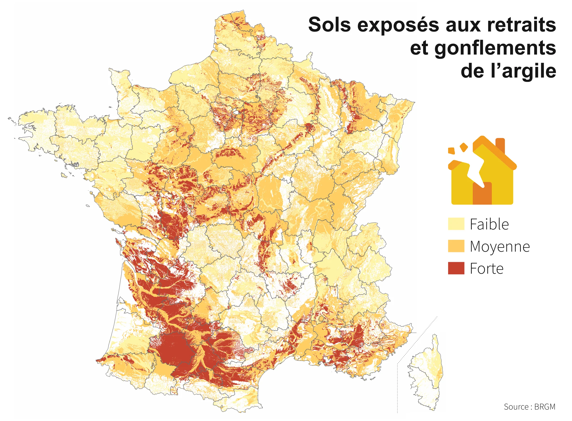
- •Southwest: Aquitaine, Midi-Pyrénées (very high hazard), due to Jurassic and Cretaceous formations rich in smectites
- •Centre-Val de Loire: limestone and marl formations from the Jurassic, medium-to-high sensitivity
- •Île-de-France: Tertiary formations (Eocene, Oligocene) showing high hazard in the Paris outer ring
- •Alsace and Lorraine: Lower and Middle Triassic formations, medium but non-negligible hazard
These areas correspond to specific geological contexts. Geotechnical research has established a correlation between the clay minerals present, their swelling potential and the depth of influence of movements. The extent of movement can reach 10 to 15 centimeters in very-high-hazard zones, directly impacting shallow building foundations.
Time evolution: how RGA is progressing
Between 2017 and 2021, several regions saw an increase in their RGA exposure, notably due to more intense drought periods and better mapping of sensitive areas. Data shows an 8 to 12% increase in areas classified as medium-to-high hazard in certain departments.
RGA evolution is not uniform. It results from several factors: first, the regular refinement of national geological databases, which allows better identification of clay formations. Second, the observable impact of climate change: repeated and prolonged droughts intensify shrinkage phenomena, revealing previously latent damage.
According to Météo-France climate projections, forecasts for 2050 indicate an increase in the frequency and intensity of extreme events (droughts, torrential rain). These sharper water variations will amplify differential ground movement, increasing risk for buildings already exposed.
- •Improved hydro-geotechnical models incorporating recent climate data
- •Integration of high-resolution piezometric measurements (groundwater depth)
- •Cross-referencing with claims inventories (INVSTAB database) to validate predictions
- •Reclassification of areas previously deemed low hazard following emerging damage
For homeowners, this evolution raises an important question: even if your region wasn't classified at risk in 2017, a later reclassification is possible. This is why vigilance remains essential, and why regular diagnoses remain important.
By department: uneven exposure
Shrink-swell hazard varies significantly from one department to another. Some, like Haute-Garonne, have over 80% of their territory exposed to high or very high hazard, while others remain lightly affected (Brittany, coastal Normandy, Savoie).
This variability reflects deep geological differences. Geological formations dating from the Jurassic and Cretaceous, rich in smectites and montmorillonites, are the most sensitive. Conversely, granitic regions (Brittany, coastal Massif Central) or pure limestone areas show limited sensitivity, since the absence of swelling clay minerals removes the shrink-swell mechanism.
Official mapping available on Géorisques includes a ranking of departments by percentage of exposure. This data helps local authorities adapt their urban planning policies and helps homeowners understand their local context. Mandatory real estate diagnoses (Alur law) systematically mention this ranking in reports.
- •Haute-Garonne: 82% of territory at medium hazard or above
- •Tarn-et-Garonne: 78% exposed
- •Haute-Vienne: 72% exposed, Middle Jurassic formations
- •Seine-et-Marne: 65% at medium hazard, Parisian Tertiary context
- •Essonne: 61% exposed, southwest belt of Île-de-France
For homeowners, the departmental index provides a first level of screening. If your department shows less than 10% of its territory at risk, your risk profile will probably be low. Conversely, a ranking above 50% justifies particular attention and an in-depth diagnosis, even before buying or selling a property.
Île-de-France: zoom on the capital region
Île-de-France involves about 2 million homes in medium-or-higher hazard zones. The Paris basin, formed of Tertiary clay layers, shows particularly high hazard in the Paris outer ring (Seine-et-Marne, Essonne, Yvelines, Val-d'Oise).
The Île-de-France region is a textbook case of urban RGA. Unlike the southwest, where the phenomenon is concentrated but extreme, the Paris region is characterized by widespread exposure to medium hazard, affecting millions of small homeowners and older residences. Tertiary geological formations (Eocene and Oligocene) contain blue-grey clay and marl layers that swell and shrink according to hydrological cycles.
Available data shows that nearly 18,000 municipalities in the Paris region have been compensated under RGA natural disaster claims between 1989 and 2023. Observed damage is mostly facade cracks (80%), followed by slab subsidence (15%) and basement swelling (5%).
- •Alternating shallow (northeast) and deep (south) groundwater zones, influencing how RGA manifests
- •Dense older urbanization favoring homes on shallow foundations (stone, plain concrete)
- •Urban vegetation (trees, gardens) contributing to soil water variation
- •Vulnerable historical heritage (19th-century homes, period houses) where repairs are costly
For residents of the Paris region, this area benefits from excellent data coverage. Local authorities (departmental councils, the city of Paris) offer prevention aid and grants for diagnoses. Awareness is also advanced: notaries and property managers systematically include RGA risk assessment in their reports.
Aquitaine: one of the most affected areas
Aquitaine (now Nouvelle-Aquitaine) is home to one of the most extreme RGA zones in France. Haute-Garonne, Tarn-et-Garonne and Haute-Vienne show very high to extreme hazard, with potential movement exceeding 15 centimeters, due to Middle and Lower Jurassic clay formations.
The reality of RGA in Aquitaine is stark. Available geological data shows that over 80% of the Haute-Garonne department rests on Jurassic formations containing smectites with very high swelling potential. This means even the newest homes, if built on shallow foundations, risk significant damage during prolonged drought periods (2003, 2012, 2022).
According to local expert reports, ground movement observed in Haute-Garonne reached 18 centimeters at certain points during the 2003 drought. Such amplitudes can crack entire foundations. This region has the highest average repair cost in the country, between €50,000 and €150,000 for an affected single-family home.
- •Outcropping Jurassic formations rich in swelling minerals (montmorillonite, dioctahedral smectite)
- •Continental climate alternating intense summer droughts and winter rainfall, creating extreme water cycles
- •Generally deep groundwater (30-50 m), amplifying surface water variations
- •Older housing stock (1950s-1980s) with inadequate foundations and little seismic reinforcement
For homeowners in Aquitaine, this extreme exposure justifies preventive measures now: regular diagnoses every 5 years, monitoring groundwater depth, strict water management around the building (gutters, drainage, controlled watering). Hydro-stabilization solutions are also gaining popularity in this region, since alternatives (micropiles) represent a huge investment incompatible with individual budgets.
What does this mapping mean for you?
RGA maps aren't fatal predictions. They are probabilistic representations of geological risk. If your home is in a high-hazard zone, this means exposure to ground movement is likely, but not certain. Several local factors play a role:
- •Your foundations: a home on deep foundations (micropiles, piles) is little affected; a home on shallow foundations runs more risk
- •Your local position: even in a high-hazard zone, some micro-areas can be spared thanks to local geology or water management
- •Your preventive action: good water management (gutters, drainage, moisture regulation) can significantly reduce risk
- •Available solutions: several approaches (hydro-stabilization, micropiles, monitoring) can limit future damage
The real usefulness of these maps? Letting you move from ignorance to action. Rather than discovering a problem during a difficult sale or after a costly claim, you can now assess your situation and put an adaptation strategy in place.
Frequently asked questions about RGA maps
Are the official Géorisques maps up to date?
Yes, official mapping is updated regularly, on average every 3 to 5 years. The last major revision dates back to 2021. However, refinement at the municipal scale remains complex, as underlying geological data (borings, surveys) doesn't cover every point of the territory. Mountain or sparsely urbanized areas are sometimes less well documented than sedimentary basins.
Can you challenge your property's classification?
Technically yes, but it's rare and complex. To do so, you would need to commission a detailed geotechnical diagnosis and present geological evidence to your local authority. This process generally costs €2,000 to €5,000 and only succeeds if local geology differs significantly from official mapping. In most cases, the official classification stands.
Why don't Île-de-France and Aquitaine have the same hazard level despite similar exposure?
It's a fine geological question. In Aquitaine, Jurassic formations contain smectites with very high swelling potential (swelling > 10%). In Île-de-France, Tertiary clays swell less (5-8%). Additionally, RGA's depth of influence varies: in Aquitaine, it can reach 20 meters; in Île-de-France, it rarely exceeds 10 meters. Hence technically different hazard levels, even though both regions are considered at risk.
How to interpret the colors on RGA maps?
Official Géorisques maps generally use four colors: blue (low hazard), green (medium hazard), orange (high hazard), red (very high hazard). These colors reflect the expected probability and intensity of ground movement. A "medium hazard" classification doesn't mean an absence of risk, but rather a less frequent or smaller-scale occurrence. Even in a low-hazard zone, older homes can suffer damage during critical years (extreme droughts).
What can I do if I am in a very-high-hazard zone?
Several options are available. First, a detailed geotechnical diagnosis to refine your local risk. Then, immediate preventive measures: strict water management, crack monitoring, gutter and drainage maintenance. Finally, depending on your means, stabilizing solutions: micropiles (heavy but reliable solution), or soil hydro-stabilization (less invasive innovative approach). Consult a geotechnical expert to adapt the solution to your case.
Sources and references
- [SOURCE 1] Géorisques - Exposure to clay shrink-swell subsidence: georisques.gouv.fr
- [SOURCE 2] Géorisques - Clay soil shrink-swell phenomenon (RGA): georisques.gouv.fr
- [SOURCE 3] Notre Environnement - Clay soil shrink-swell: notre-environnement.gouv.fr
- [SOURCE 4] DRIEAT Île-de-France - Risk linked to soil shrink-swell: drieat.ile-de-france.developpement-durable.gouv.fr
- [SOURCE 5] Nouvelle-Aquitaine Biodiversity Atlas - Regional geological data: atlas.biodiversite-nouvelle-aquitaine.fr
This article relies exclusively on public sources and verifiable scientific data. It is not a personalized geotechnical diagnosis.
Deepen your understanding
- → Understanding clay shrink-swell subsidence (RGA)
Scientific fundamentals of the phenomenon
- → RGA zones in France: are you affected?
Check your personalized exposure
- → RGA Diagnosis: assessing your exposure
Methodology and interpretation of results
- → Clay soil stabilization solutions
Intervention options and innovations