
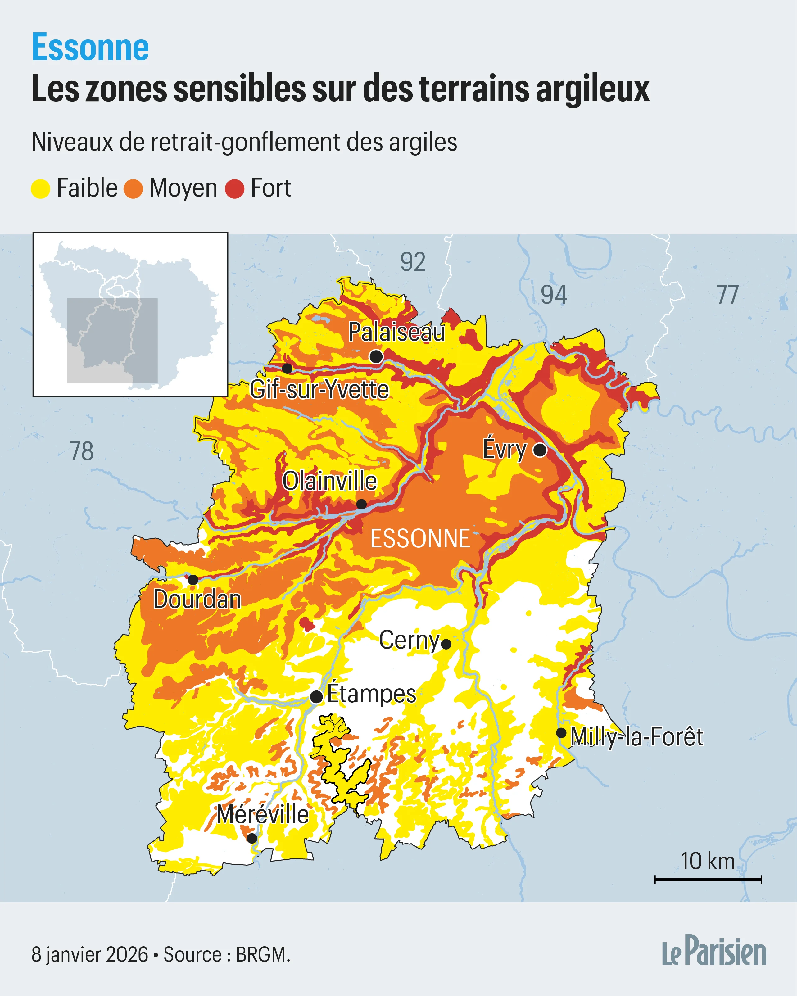
RGA in Essonne: an uneven territorial exposure
Essonne is a predominantly suburban department, with many single-family homes built between the 1970s and 2000s. Many built-up areas sit on sensitive clay soils, including densely populated sectors.
The RGA risk in Essonne is not limited to the department's rural areas. Municipalities such as Évry-Courcouronnes, Corbeil-Essonnes, Grigny, and the towns on the Saclay plateau have sectors where clay sensitivity can be significant. This geographic spread places many homeowners in a potentially exposed situation.
However, the departmental map offers a general view that does not reflect local variations at plot level. Two neighboring plots can sit on subsoils of different natures, with distinct risk levels. That's why an assessment at your exact address is needed to obtain actionable information.
Key takeaways: Essonne has many suburban areas built on clay soils; the risk affects both recent subdivisions and older buildings; the departmental map alone is not enough to assess risk at plot level.
Why Essonne is particularly exposed to RGA
Essonne largely sits on low-relief plateaus, giving a misleading impression of soil stability. This gentle topography actually masks the real sensitivity of clays to moisture variations. Contrary to what one might think, the absence of visible relief does not mean the absence of risk.
The Essonne subsoil contains sedimentary clay formations, notably green clays and marls, which show high plasticity. These materials can contract or expand depending on their water content, creating mechanical stress on building foundations.
RGA in Essonne affects recent subdivisions just as much as older homes. Structural damage can appear on buildings constructed decades ago, but also on recent buildings if geotechnical precautions were not sufficiently taken during construction.
Repeated droughts and worsening RGA in Essonne
RGA-related damage often appears after several consecutive dry summers. Cracks can show up years after construction, with no apparent triggering event.
Many Essonne residents notice cracks appearing after several dry seasons, sometimes without understanding the origin of the phenomenon. This damage is the direct consequence of the progressive drying of the clay subsoil, which causes differential contraction beneath the house.
The department has experienced several notable drought episodes over recent decades, notably in 2003, 2018, 2019, 2020 and 2022. These successive events have intensified ground movement, multiplying insurance claims. This recurrence makes appropriate monitoring and prevention all the more necessary.
A highly variable risk depending on municipality and plot
In Essonne, two neighboring homes can show very different RGA risk levels.
Essonne's geology shows great heterogeneity at the local scale. A neighborhood can include sensitive clay zones and others where soils are more stable. This variability makes any assessment based solely on municipality name or postal code illusory.
The RGA hazard maps available on Géorisques distinguish several exposure levels (low, medium, high), but these zonings remain macro-geographic indicators. At street or even plot level, the exact nature of the subsoil can differ significantly. That's why an analysis at the exact address is essential.
In addition, factors such as trees close to foundations, the rainwater drainage system, or the home's maintenance history directly influence soil behavior. Two neighboring properties can thus experience very different outcomes facing the same climate phenomenon.
What an RGA hazard rating means
It's important to remember that an RGA hazard rating is not a certainty of damage, but an increased probability of it. A plot located in a medium or high hazard zone will not automatically suffer damage, especially if preventive measures were taken during construction or if a water regulation system is in place.
Conversely, a zone classified as low hazard does not entirely rule out risk, particularly if specific local conditions (poor drainage, nearby trees, shallow foundations) favor ground movement.
The purpose of the risk assessment is therefore to identify situations where vigilance and preventive action are recommended, without causing disproportionate concern. RGA is a well-known, documented geotechnical phenomenon for which solutions exist.
Why check your risk at your address in Essonne
The departmental RGA map offers a useful general context for understanding the territory's exposure. However, it does not replace a precise analysis at the scale of your address. This fine-grained analysis is what determines whether your home actually sits on sensitive clay soil and what level of vigilance to adopt.
TerraStab uses official georeferenced Géorisques data to provide an RGA risk assessment at the exact address of your property in Essonne. This information constitutes an initial diagnosis that can guide your decisions on prevention, monitoring, or possible works.
Knowing your land's risk level also lets you anticipate potential damage, monitor the evolution of existing cracks, and put in place appropriate measures before damage becomes significant. In a department like Essonne, where RGA exposure is real and documented, this preventive approach is particularly relevant.
Frequently asked questions about RGA in Essonne
Are all municipalities in Essonne affected by RGA? No, the RGA risk varies considerably from one municipality to another, and even within the same municipality. Some areas of the department show high or medium hazard, while others are low or non-existent. An assessment at the exact address is needed to know your property's risk level.
My neighbor has cracks, am I also affected? Not necessarily. Two neighboring homes can present very different situations depending on the exact nature of the subsoil, foundation depth, presence of trees, drainage system, or land maintenance. It's recommended to have your own risk checked independently of your neighborhood's situation.
Are recent constructions in Essonne protected from RGA? Recent constructions generally comply with stricter geotechnical standards, but they are not fully immune to RGA. It all depends on the precautions taken during the soil survey and foundation design. In a medium or high hazard zone, even a recent home may require monitoring or additional preventive measures.
What should I do if my land is in a high hazard zone? A high hazard rating means an increased probability of damage, but not a certainty of a claim. You should monitor the evolution of any cracks, maintain good drainage around the house, and consider preventive solutions such as soil water regulation. TerraStab offers stabilization systems adapted to high RGA hazard zones. Learn more about stabilization solutions.
Does insurance cover RGA-related damage in Essonne? RGA damage can be covered by the natural disaster guarantee if a natural disaster order is published for your municipality. However, this recognition generally comes after the damage occurs. It is therefore preferable to adopt a preventive approach to limit risks and avoid lengthy compensation procedures.
In summary: RGA in Essonne, a risk to assess case by case
Essonne is a territory where the risk of clay shrink-swell subsidence is documented and real, but its intensity varies greatly depending on the sector and plot. A general reading by municipality or postal code is not enough: only a geolocated assessment at the address provides actionable information.
If your property is in a medium or high hazard zone, preventive solutions exist to stabilize the soil and limit differential movement. TerraStab supports Essonne homeowners in this process with water regulation systems adapted to the specifics of clay soils.
Check your risk in 30 seconds
Get a free RGA risk assessment for your address.